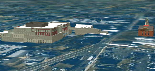
On a Thursday afternoon in January, DBI President Alan Storm and DBI Director Raj Banga attended the first-ever CityGML Workshop at Teqcorner, Northern Virginia’s premier host for technology-focused start-ups and entrepreneurs. Hosted by technology development firm Revolutionary Machines, Inc.—whose goal is “to focus on the intersection between the physical world and the information world,” the event explored the integration of data-specific applications, such as building information modeling (BIM) and geographical information systems (GIS), with CityGML, the international standard for creating, transferring, and storing three-dimensional city models. Such a synthesis of applications would augment the breadth and depth of the building, infrastructure, and geographical data within CityGML, creating a three-dimensional, browsable index of the urban built environment.
To the gathering of software developers and data scientists, Raj presented DBI’s Courthouse Square project, a 120,000-GSF, high-density commercial development to be constructed in downtown Leesburg, Virginia. The largest private development ever built in the town’s historic district, Courthouse Square will offer new Class A office and retail space, as well as a much-needed five-story parking garage, in the core of one of the fastest-growing areas in the United States. Of particular interest to the workshop crowd, however, was DBI’s presentation of its Courthouse Square Building Information Model (BIM), created in Autodesk Revit software. A vast repository of detailed, project-specific data, the model contains and analyzes various types of information about the development’s entire life cycle—from conceptual design to building management. In addition to indexing building components and detecting any areas that interfere with engineering plans, the sophistication of Revit enables us to estimate costs, perform sustainability analyses, and create coordinated sets of construction documents that link building component information to external databases for post-occupancy space and asset management.
If the meticulously detailed, building-specific data held in a BIM model, such as that of Courthouse Square, were integrated with the comprehensive descriptions provided by an urban environment’s CityGML model, the result would provide a three-dimensionally organized, searchable repository of information—a technological coupling branded by Revolutionary Machines as the “Universal Index of the Physical World ™.” This nucleus of information would be useful not only for urban modeling and spatial planning, but also for disaster response management, environmental impact analyses, navigational planning, noise emission mapping, supply chain logistics, and project-specific evaluation and management. For example, if an architect needed to locate all of the windows made by a specific manufacturer within a defined area of a city, the CityGML model, informed by other semantic databases, would be able to pinpoint every instance of that particular window. This technological integration is so promising that the European Union has established the INSPIRE (Infrastructure for Spatial Information in the European Community) initiative, which is developing interoperable spatial data applications closely related to CityGML, to determine the impact of building projects on the environment. Likewise, the Open Geospatial Consortium (OGC), an association that monitors and approves international interface requirements, has decreed CityGML as the international standard for three-dimensional city modeling.
Revolutionary Machines [themecolor] | [/themecolor] Safe Software [themecolor] | [/themecolor] CityGML [themecolor] | [/themecolor] Virtual City Systems
As an industry leader in the implementation of architectural design technology, DBI is excited to collaborate with other technology leaders, including Safe Software of Vancouver, Canada and Virtual City Systems from Berlin, Germany, whose pioneering work continually breaks new ground in the advancement of CityGML and its potential applications.


